I gotta Job too!

User avatar
Chris.G
Posts: 1124
Joined: Wed Dec 31, 1969 7:00 pm
Location: St.Pete'ish

I gotta Job too!

Post by Chris.G »

I got me a job flying a Cessna, That pays more then my Airline pilot job...Flying for a Aerial mapping and Photo company.
It's all local flying AND there is alot to be done. All low altitude, daytime nice weather.. sweeet! easy, money.

PS.

with 15mp SLR mega zoom lensed cameras.....you cant hide your fishing holes anymore...

make sure to smile :wink:
Giant- size
~ Good friends will come and bail you out of jail...Best friends will be sitting next to you saying, "Man, that was fun."~
J.P. FROG
Posts: 1467
Joined: Sat Nov 11, 2006 9:01 pm
Location: Seminole, Florida

Post by J.P. FROG »

If you fly as low as that time you buzzed me at Ft. DeSoto, you're liable to get a gulp thrown at you. :roll: :)

Congrats on the new job. You should have lots more time to fish, now.
Gary

[i]He who looks outside dreams. He who looks within awakens.[/i]
User avatar
GO-Fish
Posts: 192
Joined: Wed Dec 31, 1969 7:00 pm
Location: Fort Myers, FL

Post by GO-Fish »

Congrats Chris. Does it happen to be for Rooks?

Aerial photogrametry has become such a big business sometimes I wonder if they run into each other while flying some areas.
User avatar
wilfish
Posts: 221
Joined: Sat Sep 15, 2007 4:30 pm
Location: tampa

Post by wilfish »

Start calling you the" Tree Top Flyer" Sounds like a cool job ,Beats driving a rig .
Don't steal... The Government does not like the competition
Todd
PFTS Chairman
PFTS Chairman
Posts: 10850
Joined: Wed Dec 31, 1969 7:00 pm
Location: St. Petersburg, Florida
Contact:

Post by Todd »

Just curious but why do we need aerial phtography when we have things like google earth?

Sounds like a cool job.
User avatar
yakin-4-life
Posts: 161
Joined: Tue Mar 11, 2008 7:34 pm
Location: st. pete, fl
Contact:

Post by yakin-4-life »

be sure to post some pics of us out there fishing!!
Expectations are nothing more than predetermined disappointments.
User avatar
JoseC
Posts: 1309
Joined: Wed Jan 30, 2008 7:12 pm
Location: probably stuck at work

Post by JoseC »

congrats Chris!
Jose C

Hobie Revolution
User avatar
mudfish
Posts: 5505
Joined: Tue Sep 25, 2007 11:32 am
Location: not alot of people know.

Post by mudfish »

-Cisco-


"Great minds discuss ideas; average minds discuss events; small minds discuss people."

- Eleanor Roosevelt -
User avatar
Chadryan
Posts: 338
Joined: Fri Oct 12, 2007 9:21 am
Location: S. Tampa

Post by Chadryan »

Todd wrote:Just curious but why do we need aerial phtography when we have things like google earth?

Sounds like a cool job.
The contracting company I work for uses aerial photography quite often on our larger projects. Sometimes it is required by the owners. It is used to track progress... usually once a week or so. Google Earth can not track the progress of a live construction (or demolition in my case) site.

Here are some from when we did all the demo at NewPort... now bankrupt.

Image
Image
Image
Image
-Chad
WS Tarpon 140
Heritage Marquesa 14
noles
Posts: 1667
Joined: Wed Dec 31, 1969 7:00 pm
Location: LWR / SOTE

Post by noles »

Todd wrote:Just curious but why do we need aerial phtography when we have things like google earth?

Sounds like a cool job.
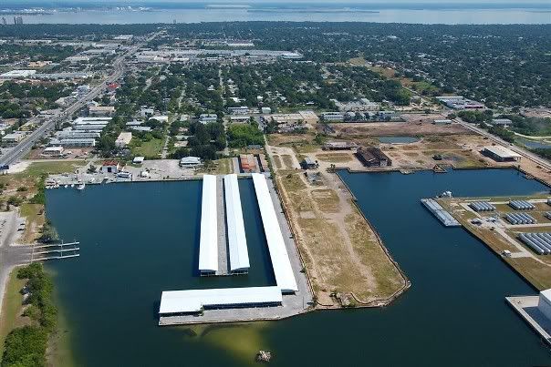
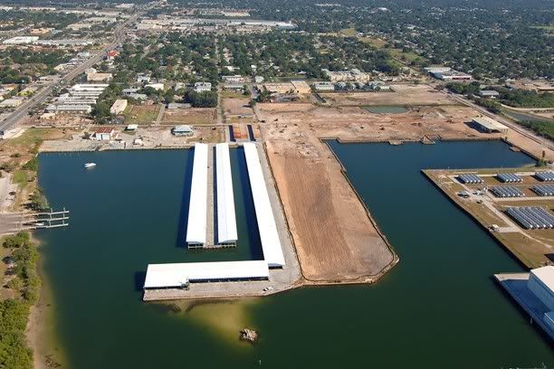
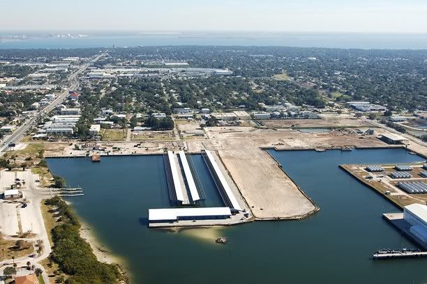
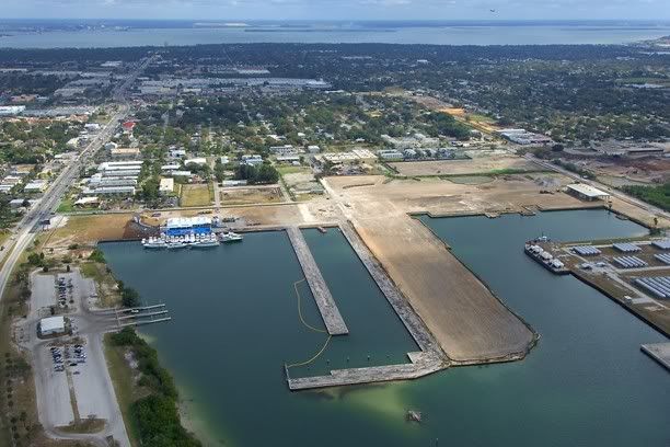
Without going into a very detail explanation, it simply comes down to the resolution of the imagery. The resolution of the imagery from Google Earth is about 3 METER and will vary depending on location. The images that Google Earth utilizes are readily available from different sources but they figured out how to package it. The resolution of the imagery from a private aerial photography firm will get you resolutions of 1 foot, even 6 inch resolution.

The aerials on Google Earth are not current either. The aerials maybe a year or two old. That's why you have a project flown.

And lastly if can't use Google Earth aerials without paying a fee if you're a business.

Here's are 1 foot resolution map:
http://maps.scgov.net/website/Image_app/viewer.htm
http://public.co.manatee.fl.us/ims/html ... ty_Locator
Last edited by noles on Fri Sep 19, 2008 3:28 pm, edited 1 time in total.
"whose that little motherf***er with the fly rod"
Rik
Posts: 14006
Joined: Wed Dec 31, 1969 7:00 pm
Location: Sarasota
Contact:

Post by Rik »

noles wrote:The aerials on Google Earth are not current either.
So true. Even though the date on the aerial in Google shows 2008, that isn't when it was taken. The aerial of my house shows a car in my driveway that my son hasn't had for 2 years.
Over every mountain there is a path, although it may not be seen from the valley
User avatar
GO-Fish
Posts: 192
Joined: Wed Dec 31, 1969 7:00 pm
Location: Fort Myers, FL

Post by GO-Fish »

Todd wrote:Just curious but why do we need aerial phtography when we have things like google earth?

Sounds like a cool job.
That is how the images you see on Google are obtained.

Google actually gets their images form various sources and yes they cna be very out of date. The images that they have for Lee County were flown in 2005, by Lee County. If you go to the Lee County GIS site they have the 2007 images available (these are 0.5 foot resolution (1 pixel = 6")
http://leegis.leegov.com/LeeSpInS/viewer.htm click on the image link on the right and you will see how many times Lee County is flown. This is very important for areas that these is a lot of development on.

Google obtains the images from various government sources (often for no charge)

Lee County has all the major projects flown for progress photographs. These are usually done by helicopter.

Aerial photogrametry is often used to produce topo maps used in survey work, rather than spend time on the ground surveying a road or site they can fly it and produce the 3d information needed for design plans.

A pretty good job to have since they only fly in good weather, since clouds obscure images of the ground. Good luck!
User avatar
CooKnFish
Posts: 3156
Joined: Wed Dec 31, 1969 7:00 pm
Location: South Shore
Contact:

Post by CooKnFish »

J.P. FROG wrote:If you fly as low as that time you buzzed me at Ft. DeSoto, you're liable to get a gulp thrown at you. :roll: :)
Who needs an RPG when ya can fill a prop with Power Pro! :lol:
Paddles - they aren't just for the bedroom anymore.

~Mark~
LivelyBaits
Posts: 8531
Joined: Wed Dec 31, 1969 7:00 pm
Contact:

Post by LivelyBaits »

I wondered if it was Chris G today, circling us on the water. It was pretty funny because the guy was obviously trying to lay his shadow right across our boats (very well I might add).

Congrats Chris. Kenny, though no relation, would be so proud! :wink:
pee-dash-eff, "Desperate. H.W"
User avatar
Chris.G
Posts: 1124
Joined: Wed Dec 31, 1969 7:00 pm
Location: St.Pete'ish

Post by Chris.G »

Thanks guys. Actually I'm on my last 6 day trip here at Continental Express. I should be home late enough on sunday to see the last few plays of the late game. Tonight I'm in the sprawling metropolis of Gulfport,MS. tomorrow I get some real Mexican food In San Luis Potosi.

I am excited to get some easy work, close to home. If I happen to buzz some of you. you'll know it's me by the Giant white MOON on the left side of the plane....... :wink:
Giant- size
~ Good friends will come and bail you out of jail...Best friends will be sitting next to you saying, "Man, that was fun."~
User avatar
Redfisher
Posts: 3516
Joined: Wed Dec 31, 1969 7:00 pm

Post by Redfisher »

I can see the headlines now. A small plane goes down at Fort Desoto. The pilot was fine because he had some how wedged his bare ass in the window for protection. :D
Senior Exalted Pro Staff Member of the Paddle-Fishing.com Kayak & Canoe Anglers Club
Post Reply