GPS/Chart Plotter with most of Florida for only $9.99 (long)

Have rigging questions or a good idea? Found a good fishing product? Tell us about it.
Post Reply
User avatar
fishcometrue
Posts: 10
Joined: Fri May 22, 2009 7:55 am
Location: Valrico, Florida

GPS/Chart Plotter with most of Florida for only $9.99 (long)

Post by fishcometrue »

Ok here is my latest find. First of all I don't work for Apple or Navionics. If you have an iPhone or need to be able to cost justify one here it is. I told my wife it would make it easier for the Coast Guard to find her boys. :) It worked.

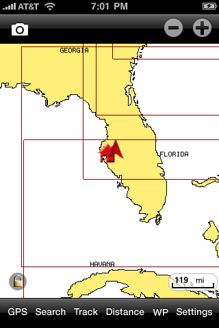
Navionics has an app for iphone that includes the charts from just below Cedar Key down to the Keys and back up to South Carolina. All included for the one time cost of $9.99. Amazing. The entire US/Carribean is available for additional $9.99 charges for each chart zone.

Here are some screen shots of the functions.... It works in typical iphone fashion with touch and tap navigation. Flawless IMHO. It refreshes and tracks faster than I can change channels on the T.V.
Image
Tappin the screen or using the + / - at the top lets you zoom down from 10,000 feet to the top of a greenback's dorsal fin. :)
Image
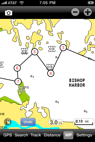
You can tap and add way points for navigation and route back...or to mark a productive spot. You can also drop pins and add photos/comments to favorite spots.
Image
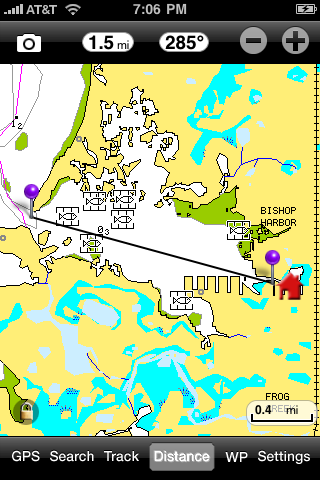
taping the distance field on the bottom displays two pins that can be dragged apart and placed on locations. The distance is displayed up top with a compass heading. You can also tap distance from current GPS spot. Funny how paddling a mile can seem like 5 into the wind. :) This feature is great for putting a ruler to that distant spot.
Image
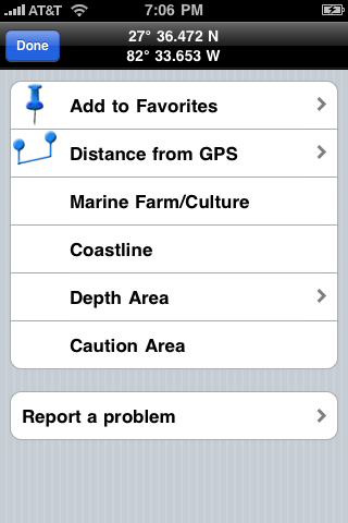
Screen shot of detail menu
Image
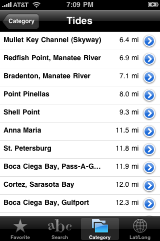
Tide prediction by location and distance from current location.
Image
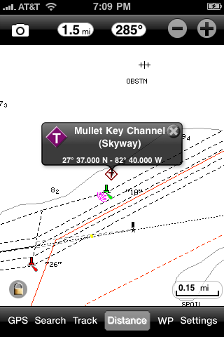
Tappin on the "T" icon for Tide gives you the following detail...
Image
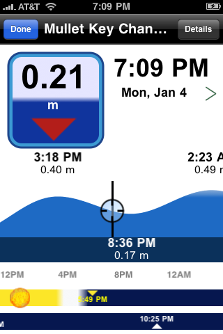
the black circle/crosshairs are slidable and move along the the blue tide curve, the sunrise sunset info changes as well.

The static screen shots really don't show the functionality of the app. These are just some highlights. For under 10 bones its a deal. I have my iphone in an otterbox case (water resistant sorta) then slip it into a west marine electronics waterproof pouch. The touch slide/tap screen is still functional. The pouch comes with a lanyard and I put it around my neck.

Additionally, the tracking feature draws a real time red line across the chart tracking your paddle. Good for the those "heavy mangrove get lost easy places" like 10,000 Islands.

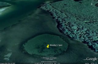
This might be cheating and or obvious, but using Google Earth you can zoom in on holes/structure and grab the Lat and Lon enter it into the iphone and start paddling. Could make finding holes easier when visibility is down, wind up etc....
Image
Todd
PFTS Chairman
PFTS Chairman
Posts: 10850
Joined: Wed Dec 31, 1969 7:00 pm
Location: St. Petersburg, Florida
Contact:

Post by Todd »

I have that also, amazing tools.

Just having access to google earth is a huge plus, It really comes in handy when you fish outside of your normal areas.

I have one of these, works great.

http://www.drycase.com/
You know what La Quinta means in English? Behind Dennys. MarkM
User avatar
fishcometrue
Posts: 10
Joined: Fri May 22, 2009 7:55 am
Location: Valrico, Florida

Pack

Post by fishcometrue »

Looks just like the one at West Marine... probably the OEM for it. I think i paid 14.00 Im sure it had the WM premium up charge. :) Im looking at the DigiPac camera bag. Saw a guy using one on vacation... he had good things to say about it.
Todd
PFTS Chairman
PFTS Chairman
Posts: 10850
Joined: Wed Dec 31, 1969 7:00 pm
Location: St. Petersburg, Florida
Contact:

Post by Todd »

I won it in a raffle. Have no idea how much they cost, just know they work.
You know what La Quinta means in English? Behind Dennys. MarkM
ChrisR
Supporter 2010 - 2014
Posts: 1203
Joined: Sat Jan 05, 2008 3:06 pm
Location: under my lone palm

Post by ChrisR »

I'll have to look into this app. Looks pretty nice. Thanks for the heads up!

I bought a similar dry sac at BassPro for $10. I have seen them at Walmart as well.
User avatar
mudfish
Posts: 5505
Joined: Tue Sep 25, 2007 11:32 am
Location: not alot of people know.

Post by mudfish »

Pretty darn slick!

Which version is it you speak of? I can't find a "Marine: US South"? Only a "Marine: US East", but that goes from FL up to Maine, not what you've described. :?
-Cisco-


"Great minds discuss ideas; average minds discuss events; small minds discuss people."

- Eleanor Roosevelt -
Todd
PFTS Chairman
PFTS Chairman
Posts: 10850
Joined: Wed Dec 31, 1969 7:00 pm
Location: St. Petersburg, Florida
Contact:

Post by Todd »

Marine US East covers the west coast of Florida.
You know what La Quinta means in English? Behind Dennys. MarkM
User avatar
fishcometrue
Posts: 10
Joined: Fri May 22, 2009 7:55 am
Location: Valrico, Florida

Post by fishcometrue »

I think that is the one... But scroll down in the app purchase section in apps untill you see the screen shots. Slide over to the right and you will see the coverage area of each app. I might of been off on my boundries but it's a butt load of charted waters and includes almost all of Florida.
Todd
PFTS Chairman
PFTS Chairman
Posts: 10850
Joined: Wed Dec 31, 1969 7:00 pm
Location: St. Petersburg, Florida
Contact:

Post by Todd »

I checked with Navionics, that is the one. I could not remember either.
You know what La Quinta means in English? Behind Dennys. MarkM
User avatar
mudfish
Posts: 5505
Joined: Tue Sep 25, 2007 11:32 am
Location: not alot of people know.

Post by mudfish »

Thanks for clearing that up guys. :wink:
-Cisco-


"Great minds discuss ideas; average minds discuss events; small minds discuss people."

- Eleanor Roosevelt -
User avatar
krash
Supporter 2010 - 2014
Posts: 920
Joined: Wed Dec 31, 1969 7:00 pm
Location: Cooper City, Florida USA

Re: GPS/Chart Plotter with most of Florida for only $9.99 (l

Post by krash »

I have a Nexus 5, Andriod, phone and downloaded/installed this app. yesterday but the closest app/version was for Marine & Lakes USA, looks like it includes the entire USA Coastal areas and most named lakes.. $9.99

Looks good on a simple static look, moving the cursor.. hope it actually integrates with the Google gps/maps on this phone.

Anyone using it with Andriod or more specifically the Nexus phone ?
Senior Exalted Pro Staff Member of the Paddle-Fishing.com Kayak & Canoe Anglers Club

SW, Live to Fish, Have Tackle will travel ... >,)))~> ~~~~
Post Reply