TROPICAL WEATHER OUTLOOK
NWS NATIONAL HURRICANE CENTER MIAMI FL
800 AM EDT SAT JUN 23 2012
FOR THE NORTH ATLANTIC...CARIBBEAN SEA AND THE GULF OF MEXICO...
THE CENTER OF CIRCULATION OF THE BROAD AREA OF LOW PRESSURE OVER THE
GULF OF MEXICO APPEARS TO BE BECOMING BETTER DEFINED ABOUT 275
MILES SOUTH-SOUTHEAST OF THE MOUTH OF THE MISSISSIPPI RIVER. IN
ADDITION...SHOWERS AND THUNDERSTORMS HAVE BEEN INCREASING OVER THE
EASTERN GULF OF MEXICO...AND A NOAA BUOY LOCATED ABOUT 130 MILES
EAST-NORTHEAST OF THE CENTER HAS PRODUCED TROPICAL-STORM-FORCE
WINDS WITHIN THE PAST COUPLE OF HOURS. A TROPICAL DEPRESSION...OR
MORE LIKELY A TROPICAL STORM...COULD FORM LATER TODAY OR TONIGHT IF
THE DEVELOPMENT TREND CONTINUES. THIS SYSTEM HAS A HIGH CHANCE....90 PERCENT...OF BECOMING A TROPICAL CYCLONE AS IT MOVES SLOWLY
NORTHWARD DURING THE NEXT 48 HOURS.
TROPICAL STORM WATCHES OR WARNINGS COULD BE REQUIRED FOR A PORTION OF THE NORTHERN GULF COAST OVER THE WEEKEND...AND INTERESTS IN THIS
AREA SHOULD CONTINUE TO MONITOR THE PROGRESS OF THIS LOW. HEAVY
RAINS AND LOCALIZED FLOODING ARE POSSIBLE ACROSS THE YUCATAN
PENINSULA...WESTERN CUBA...AND MUCH OF FLORIDA OVER THE NEXT DAY OR
SO. AN AIR FORCE RESERVE RECONNAISSANCE AIRCRAFT IS SCHEDULED TO
INVESTIGATE THE SYSTEM THIS AFTERNOON.
ELSEWHERE...TROPICAL CYCLONE FORMATION IS NOT EXPECTED DURING THE
NEXT 48 HOURS.
$$
FORECASTER BERG
The GFS says we'll have Debby
Re: The GFS says we'll have "Debbie"
35/34.5/26 24/22/1/1
I finally found Cow Creek. It's at the end of the Road to Nowhere!
I finally found Cow Creek. It's at the end of the Road to Nowhere!
Re: The GFS says we'll have "Debbie"
This is from Bryan Norcross' Facebook page:
Still on track and still just as confused a forecast for the Gulf system this morning. Winds in the Gulf have been measured right at tropical-storm strength, so the NHC might skip the Tropical Depression stage and go right to Tropical Storm Debby when it gets sufficiently organized. Right now, the upper winds are just unfavorable enough to limit organization (and they are pushing the rain toward... Florida). They are expected, however, to become somewhat more favorable, though not perfect, giving the system a chance to fully consolidate around the center. The first area of concern will be the northern Gulf. Flooding high tides, high waves, and dangerous beach conditions are expected. Watch for local warnings. The storm is expected to stay in the northern Gulf until Monday, then move either toward Florida or toward Texas/Mexico. When the NHC puts out its first track forecast, it will be interesting to see which scenario they choose. There is logic to each of them... though the historically best-performing model is the one aiming toward TX/MS. Stay tuned.
And this from Dr. Jeff Masters discussion this morning:
Forecast for 96L
Wind shear is predicted to remain in the moderate range through Sunday night, which is likely low enough to allow 96L to develop into a tropical depression or tropical storm by Sunday; NHC gave 96L a 90% chance of developing into a tropical depression by Monday morning, in their 8am EDT Tropical Weather Outlook. The future path of 96L is still unclear. The disturbance will drift slowly northwards through Sunday night, which will likely bring heavy rains of 2 - 4 inches to the Gulf Coast from Central Louisiana to Central Florida. A storm surge of 1 - 3 feet is also likely along the Southeast Louisiana coast on Sunday; coastal flood advisories have already been posted there. By Monday, the majority of the reliable models, including the ECMWF, NOGAPS, HWRF, and UKMET, agree that a ridge of high pressure will build in over the Southern U.S., forcing 96L westwards across the Gulf of Mexico and into South Texas by Wednesday. However, the GFS model, which has been our 2nd most reliable track model over the past two years (behind the ECMWF), has consistently been predicting that a trough of low pressure pushing off of the U.S. East Coast will be capable of grabbing the disturbance and accelerating it to the northeast across Florida north of Tampa Bay on Monday. The GFDL model splits the difference between these extremes, taking 96L northwards to a landfall near the Alabama/Florida border on Tuesday. Given that the majority of the models predict a westward track to Texas, that should be viewed as the most probable path for 96L, but this is a low-confidence forecast.
None of the models is predicting 96L will become a hurricane, and the SHIPS model is predicting just a 4% chance of rapid intensification for 96L. Given the moderate levels of wind shear and dry air over the Gulf, only slow to modest intensification of 96L is likely over the next few days.
35/34.5/26 24/22/1/1
I finally found Cow Creek. It's at the end of the Road to Nowhere!
I finally found Cow Creek. It's at the end of the Road to Nowhere!
Re: The GFS says we'll have "Debbie"
Interesting comments from a professional meterologist giving the reasoning behind why Debby might head more torward Florida:
...As I sat here looking at the satellite loop and the shear, one thing did occur to me. Even though I think the upper levels are conducive for a movement to the west eventually...we could get into one of those situations where the center reforms and reforms...and gets tugged east and NE by convection. So much so that it really does go NE into FL.
The steering wouldnt take it there...but maybe that is what the GFS is picking up on. Don't know. This may be one of those situations where the low is constantly getting tugged by the convection to the NE and E and before you know it...it works its way into the break in the ridge.
35/34.5/26 24/22/1/1
I finally found Cow Creek. It's at the end of the Road to Nowhere!
I finally found Cow Creek. It's at the end of the Road to Nowhere!
Re: The GFS says we'll have "Debbie"
From the NHC:
...TROPICAL STORM DEBBY FORMS IN THE CENTRAL GULF OF MEXICO... ...TROPICAL STORM WARNING ISSUED FOR A PORTION OF THE LOUISIANA COAST...
btw - there have been two tornado warnings issues in SW FL already.
...TROPICAL STORM DEBBY FORMS IN THE CENTRAL GULF OF MEXICO... ...TROPICAL STORM WARNING ISSUED FOR A PORTION OF THE LOUISIANA COAST...
btw - there have been two tornado warnings issues in SW FL already.
35/34.5/26 24/22/1/1
I finally found Cow Creek. It's at the end of the Road to Nowhere!
I finally found Cow Creek. It's at the end of the Road to Nowhere!
Re: The GFS says we'll have "Debbie"
AREA FORECAST DISCUSSION
NATIONAL WEATHER SERVICE TALLAHASSEE FL
946 PM EDT Sat Jun 23 2012
.NEAR TERM [through Tonight]...
It appeared that the center of Debby was moving northeast in the
last couple of visible satellite pics of the day. However, we are
attributing that to a wobble and anticipate little movement with
this system during the overnight hours. However, if the trend does
not reverse itself, then we may need to finally consider the
possibility that the GFS solution (which we have been routinely
discounting for days) may have some merit. That said, both this
office and the national hurricane center continue to feel that an
eventual turn to the west is expected as the large upper level ridge
over the Southern Plains builds.
35/34.5/26 24/22/1/1
I finally found Cow Creek. It's at the end of the Road to Nowhere!
I finally found Cow Creek. It's at the end of the Road to Nowhere!
Re: The GFS says we'll have "Debbie"
Debby has strengthened. Some oil rigs have been evacuated and TS warnings going up.
I think I'll need my kayak to travel on Anna Maria during high tide this afternoon!
http://www.wunderground.com/tropical/at ... ublic.html
I think I'll need my kayak to travel on Anna Maria during high tide this afternoon!
http://www.wunderground.com/tropical/at ... ublic.html
35/34.5/26 24/22/1/1
I finally found Cow Creek. It's at the end of the Road to Nowhere!
I finally found Cow Creek. It's at the end of the Road to Nowhere!
Re: The GFS says we'll have "Debbie"
watches and warnings
--------------------
changes with this advisory...
a Tropical Storm Warning has been extended eastward along the
northwest coast of Florida to the Suwannee River.
A tropical storm watch has been issued south of the Suwannee River
to Anclote Key.
Summary of watches and warnings in effect...
a Tropical Storm Warning is in effect for...
* the coast of Louisiana from the mouth of the Pearl River westward
to Morgan City...not including the city of New Orleans or Lake
Pontchartrain
* the Mississippi-Alabama border eastward to the Suwannee River
river Florida
a tropical storm watch is in effect for...
* south of the Suwannee River to Anclote Key Florida
a Tropical Storm Warning means that tropical storm conditions are
expected somewhere within the warning area within 36 hours.
A tropical storm watch means that tropical storm conditions are
possible within the watch area...in this case within 12 to 24 hours.
For storm information specific to your area...including possible
inland watches and warnings...please monitor products issued by
your local National Weather Service forecast office.
Discussion and 48-hour outlook
------------------------------
at 1000 am CDT...1500 UTC...the center of Tropical Storm Debby was
located near latitude 28.0 north...longitude 86.2 west. Debby is
moving toward the northeast near 6 mph...9 km/h...but little motion
is expected during the next 12 to 24 hours. A gradual turn toward
the west is forecast thereafter. The forecast track will keep the
center of Debby meandering over the northern Gulf of Mexico during
the next few days.
Maximum sustained winds are near 60 mph...95 km/h...with higher
gusts. Some slight strengthening is possible during the next 48
hours.
Tropical-storm-force winds extend outward up to 200 miles...325 km
from the center mainly to the north and east of the center. Bald
Point in the Florida Big Bend recently reported sustained winds of
52 mph...84 km/h.
The latest estimated minimum central pressure from a reconnaissance
aircraft was 994 mb...29.35 inches.
Hazards affecting land
----------------------
wind...tropical storm conditions are already near or over portions
of the northeast Gulf Coast and are expected to reach the remainder
of the warning area by tonight...making outside preparations
difficult or dangerous.
Storm surge...the combination of a storm surge and the tide will
cause normally dry areas near the coast to be flooded by rising
waters. The water could reach the following depths above ground if
the peak surge occurs at the time of high tide...
Southeastern Louisiana eastward through Apalachee Bay...3 to 5 ft
Florida West Coast south of Apalachee Bay...1 to 3 ft
southwestern Louisiana...1 to 3 ft
The deepest water will occur along the immediate coast in areas of
onshore flow. Surge-related flooding depends on the relative
timing of the surge and the tidal cycle...and can vary greatly over
short distances. For information specific to your area...please
see products issued by your local National Weather Service office.
Rainfall...Debby is expected to produce rain accumulations of 5 to
10 inches along the immediate Gulf Coast from southeast Louisiana
to the central West Coast of Florida...with isolated maximum
amounts of 15 inches possible. Given the recent heavy rainfall and
wet soil conditions...these additional amounts will exacerbate the
flash flood threat across portions of the central and eastern Gulf
Coast.
Tornadoes...isolated tornadoes are possible over portions of the
west-central and southwestern Florida Peninsula today.
Next advisory
-------------
next intermediate advisory...100 PM CDT.
Next complete advisory...400 PM CDT.
$$
Forecaster Avila
View All Tropical Weather
35/34.5/26 24/22/1/1
I finally found Cow Creek. It's at the end of the Road to Nowhere!
I finally found Cow Creek. It's at the end of the Road to Nowhere!
Re: The GFS says we'll have Debby
Check out this infrared loop...

Last edited by Tide1on on Sun Jun 24, 2012 12:57 pm, edited 1 time in total.
NATIVE Redfish14
Your Wallet - The one place Democrats are willing to drill
Steve
Your Wallet - The one place Democrats are willing to drill
Steve
-
Mike Hodge
- Posts: 130
- Joined: Wed Jan 19, 2011 6:36 pm
- Location: Tampa
-
Mike Hodge
- Posts: 130
- Joined: Wed Jan 19, 2011 6:36 pm
- Location: Tampa
Re: The GFS says we'll have Debby
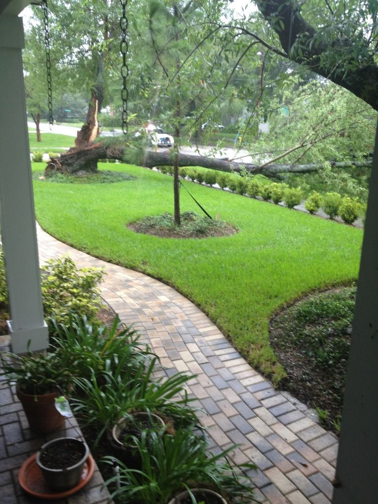
First picture posted. Finally got with the 21st century. All it took was a tree crashing down in our front yard a few minutes. One of the few times I'm glad to be a renter as opposed to a homeowner.
Re: The GFS says we'll have Debby
Mike - I'm glad it fell toward the street!
It's been really bad out here on Anna Maria Island for several hours. It's almost high tide in the Gulf and the waves on top of an abnormally high tide are taking away quite of beach. I'd guess we've lost 3 feet and it seems worse than the Charley-Frances-Jeanne year. I'm wondering if any of the many turtle nests will survive. : (
SUMMARY OF 100 PM CDT...1800 UTC...INFORMATION
----------------------------------------------
LOCATION...28.3N 85.9W
ABOUT 200 MI...325 KM ESE OF THE MOUTH OF THE MISSISSIPPI RIVER
ABOUT 105 MI...170 KM SSW OF APALACHICOLA FLORIDA
MAXIMUM SUSTAINED WINDS...60 MPH...95 KM/H
PRESENT MOVEMENT...NE OR 40 DEGREES AT 5 MPH...7 KM/H
MINIMUM CENTRAL PRESSURE...993 MB...29.32 INCHES
35/34.5/26 24/22/1/1
I finally found Cow Creek. It's at the end of the Road to Nowhere!
I finally found Cow Creek. It's at the end of the Road to Nowhere!
Re: The GFS says we'll have Debby
We have a total breach of bay water across Gulf Drive somewhere around 30th St. in Bradenton Beach. I have several limbs down in my yard and a couple of trees down on the island. My daughter rescued half of a turtle nest that was being uncovered by waves. Several roads closed. This is the worst flooding I've seen on the island.
NHC 5PM forecast now takes it due north (and extends the TS watch south through the Tampa Bay area to Englewood):
FORECAST VALID 25/0600Z 28.7N 85.5W
MAX WIND 50 KT...GUSTS 60 KT.
50 KT... 25NE 25SE 0SW 25NW.
34 KT...175NE 150SE 40SW 100NW.
FORECAST VALID 25/1800Z 29.0N 85.5W
MAX WIND 50 KT...GUSTS 60 KT.
50 KT... 25NE 25SE 0SW 20NW.
34 KT...150NE 150SE 40SW 100NW.
FORECAST VALID 26/0600Z 29.0N 85.5W
MAX WIND 55 KT...GUSTS 65 KT.
50 KT... 25NE 25SE 0SW 25NW.
34 KT...150NE 150SE 40SW 100NW.
FORECAST VALID 26/1800Z 29.0N 85.5W
MAX WIND 60 KT...GUSTS 75 KT.
50 KT... 25NE 25SE 0SW 25NW.
34 KT...120NE 120SE 40SW 75NW.
FORECAST VALID 27/1800Z 29.5N 85.5W
MAX WIND 60 KT...GUSTS 75 KT.
50 KT... 25NE 25SE 0SW 25NW.
34 KT...120NE 120SE 40SW 90NW.
EXTENDED OUTLOOK. NOTE...ERRORS FOR TRACK HAVE AVERAGED NEAR 175 NM
ON DAY 4 AND 225 NM ON DAY 5...AND FOR INTENSITY NEAR 20 KT EACH DAY
OUTLOOK VALID 28/1800Z 30.0N 85.5W
MAX WIND 40 KT...GUSTS 50 KT.
OUTLOOK VALID 29/1800Z 30.5N 85.5W...INLAND
MAX WIND 30 KT...GUSTS 40 KT.
35/34.5/26 24/22/1/1
I finally found Cow Creek. It's at the end of the Road to Nowhere!
I finally found Cow Creek. It's at the end of the Road to Nowhere!
Re: The GFS says we'll have Debby
Terry it just occurred to me, your initials "TW" must also stand for...
Tropical Weather.
Tropical Weather.
NATIVE Redfish14
Your Wallet - The one place Democrats are willing to drill
Steve
Your Wallet - The one place Democrats are willing to drill
Steve
Re: The GFS says we'll have Debby
Hah, Steve, that's a good one. I've had enough of Debby & hope we have no more injuries or fatalities! It's hard to believe she is weakening. We had our first quiet weather in the middle of the night but it's been screaming again for hours.
NHC - 5 am EDT:
000
WTNT34 KNHC 250836
TCPAT4
BULLETIN
TROPICAL STORM DEBBY ADVISORY NUMBER 8
NWS NATIONAL HURRICANE CENTER MIAMI FL AL042012
400 AM CDT MON JUN 25 2012
...DEBBY A LITTLE WEAKER WHILE REMAINING NEARLY STATIONARY OVER THE
NORTHEAST GULF OF MEXICO...
SUMMARY OF 400 AM CDT...0900 UTC...INFORMATION
----------------------------------------------
LOCATION...28.6N 85.8W
ABOUT 90 MI...145 KM SSW OF APALACHICOLA FLORIDA
MAXIMUM SUSTAINED WINDS...50 MPH...85 KM/H
PRESENT MOVEMENT...STATIONARY
MINIMUM CENTRAL PRESSURE...993 MB...29.32 INCHES
35/34.5/26 24/22/1/1
I finally found Cow Creek. It's at the end of the Road to Nowhere!
I finally found Cow Creek. It's at the end of the Road to Nowhere!
-
sfurman
- Supporter 2010 - 2013
- Posts: 1214
- Joined: Wed Dec 31, 1969 7:00 pm
- Location: Tampa, Steinhatchee
Re: The GFS says we'll have Debby
Okay, okay, that's enough rain already, geeze I didn't mean stall out and sit there and drown us. Be careful what you ask for..
My posts are my opinion only.
Steve
Steve
Re: The GFS says we'll have Debby
No changes with the 8 am. There is still quite a bit of rain in bands down toward Cuba. If Debby stays stationary or moves north, we should still get more rain. Ouch.
It will be interesting to see if she crosses FL into the Atlantic and strenghtens. Personally, I'd like her to die a quick death.
It will be interesting to see if she crosses FL into the Atlantic and strenghtens. Personally, I'd like her to die a quick death.
35/34.5/26 24/22/1/1
I finally found Cow Creek. It's at the end of the Road to Nowhere!
I finally found Cow Creek. It's at the end of the Road to Nowhere!